
As if being on an island wasn’t enough separation, don’t be surprised to hear people talking about Cascadia. Decades ago, an author published a book, Ecotopia , about parts of the west coast of North America breaking off from the rest of the continent’s governments because a crisis occurred. Feeling distant from the mainstream, and feeling ignored in a time of need, they broke off into a separate country. The idea continues to resonate, usually under the name, Cascadia; which was refreshed with Washington’s, Oregon’s, and California’s collaboration to counter the coronavirus. The initiative is called the Western States Pact. The echoes are similar, but the reality is more complicated, naturally.
Essentially, Cascadia is a secessionist movement. The difference, however, is that there are precedents that allow peaceful transitions. Countries peacefully annexing properties don’t get as much attention as the less peaceful actions. Consider the Louisiana Purchase and Alaska. The US bought land from other countries. The opposite is possible, too. There are several such scenarios that are peaceful and legal, though uncommon.
Cascadia has other names (Ecotopia, Rainier, Columbia, etc.) They all tend to include Seattle and Portland, but have different northern, southern, and eastern borders. To the north, it makes sense to draw the line at the current Canadian border, or add the Salish Sea part of British Columbia definitely including Vancouver and Victoria, or all of British Columbia, or adding whatever parts of Alaska want to come join. The the south, it is easy to draw the border at the California border, or maybe including the area with similar forests and volcanoes, or the Bay Area, or the entire state of California as is included in the Western States Pact, or add at least Baja, Mexico. The eastern boundaries typically end at the eastern borders of each of the states and provinces.


Common economies, similar value systems, contiguous territory, integrated natural environments. Makes sense, right? The Left Coast finally has a more unified voice than trying to compromise with the East, the Plains, the Gulf, and the South. Right?
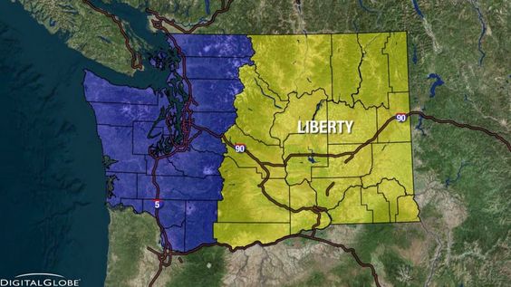
Maybe not so right. Even just Washington State has significant differences between east and west that the eastern part of the state is discussing seceding from the western part of the state. Spokane and Seattle aren’t copies. Each has a different economy, environment, and culture. Those in favor of the new State of Liberty draw their western border at convenient county borders that follow the ridge of the Cascade Mountains.
The differences between the urban coast and the rural lands inland are recognized in each of the states (and provinces.) One analyst drew borders based on common cultures. The eastern border was basically along the ridgeline. The southern border reached down to just north of the LA area. The northern border extended beyond the top of map and included most or all of British Columbia.
Arguments can be made for many shapes. When it is academic, or an exercise limited to colored pens drawing paper maps, a line is easy to draw. Have fun. Do it yourself. Anyone can play.
The reality of the complexity is demonstrated on Whidbey Island. Click back to Two Ends Same Island. In addition to the various economic and demographic differences listed there, political and cultural differences exist, too. Some people won’t even travel to the other end of the island because it seems too foreign. Even islanders who recognize the differences don’t agree on the border: Oak Harbor city limits, Monroe Landing, Penn Cove, OLF, Race Road, Ledgewood, Greenbank Farm, or the iconic Whidbey Tel phone booth (operating for free local calls!) at Classic Road? There is also the significant land owner that is the US government, which might not approve of the changes. (Though everything has its price.)
For a hint of the diversity involved throughout the region, carefully browse the subReddit group for Cascadia.
Cascadia and its variants have a variety of maps. Cascadia is not a government, so no one can govern how people paint a piece of fabric and fly it. If anything was to change, it probably would take a long time, unless Washington the District of Columbia got impulsive and disgusted with Washington the state that happens to include the Columbia River – or if someone wrote a big enough check.

As you travel the island look for the flags. Most are variants of a tall conifer on green, white, and blue striped field (did they consult the Seahawks, or is that where the football team got its colors?).
As to whether anything will ever happen with redrawing country boundaries, the topic of the presentation in the previous post and video was simple: the only constant is change.
PS A factoid that just came to mind. The Louisiana Purchase happened because one country had so much debt that they had to sell land for cash. Would selling off the US West Coast get the US out of debt? Hmm. Something to research.

As always, Tom, I enjoyed your perspective! I’ve never commented or “liked” one of your blog posts, but in order to that, I’d have to set up an account, which I don’t really want to do. So I’m replying to the email in hopes that this is a way I can let you know how much I enjoy your blog. (at least this one! The Pretending Not To Panic one is a little too real for me…)
I hope you’re healthy and well!
Warmly, Lynne
>
LikeLike