
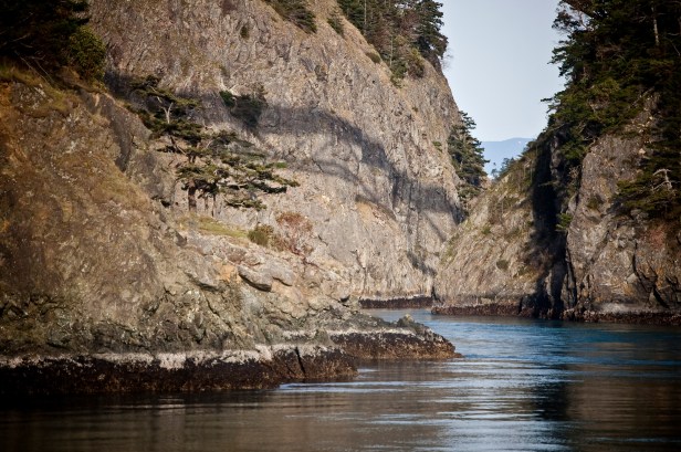
Believe it or not, Whidbey Island’s nickname is “The Rock.” Easy to believe at Deception Pass. A reason to shrug shoulders for most of the rest of the island. Whidbey Island has some impressive rocks, but a lot is rubble, sand, and clay. It’s a topic that’s rarely mentioned, but the island’s geology reaches into earthquake impacts, infrastructure needs, and gardener’s concerns. And then, there are the erratics.
Look at Deception Pass. Cliffs stout enough to strongly stand against ever-present tidal erosion. A great location for an iconic bridge, one of the more vital links to the island. The Rock.
Just a few miles south, however, it becomes a land of steep bluffs and shallow bays.
Penn Cove

Admiralty Head

Double Bluff

Cultus Bay

Sand, and clay, and gravel. At least they are handy materials for ceramics and construction. Their distribution also affects foundations, septic systems, and drainages. If everything was the same everywhere, there probably wouldn’t be a need to dig yet another set of perc pits, holes dug to assess the permeability of the soil and its ability to sustain a septic field.
Blame the glaciers for the distribution. The bedrock at the north end remains exposed and above sea level, dramatically. But, 3,000 feet of ice can bulldoze anything down to rubble. The glaciers bulldozed the land, scrambled it all together, then meltwater and the eventual retreat redistributed the remains into gullies and ravines that may have been scraped more than once. The mix is a mess.
Most residents don’t care. Grow where you’re planted, or at least that’s what they tell their plants. OK, so they do care, but land usually is bought based on other criteria than soils alone. For the determined gardeners, and more particularly for farmers, there’s a soil survey that can numb most minds, but answer lots of detailed questions for those who know what to ask.
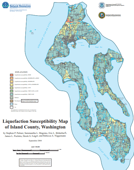
Residents might be more interested in the liquefaction map, the cautionary production that estimates which land will be most susceptible to getting a bit less solid, at least during a quake. The island has some areas that are highly susceptible, particularly near the Naval Air Station. But the majority of the island is marked as Very Low, a welcome condition considering the lack of bedrock. Look at the top nubbin of the island for one of the few bedrock outcrops. (That’s easier to see on the bigger version, available on the County web site.)
As for big boulders, rocks that are too much to move, there are so many erratic leftovers from the glaciers that they warrant their own wikipedia page. Wander around the island and witness how messy glaciers can be. They took littering to another level.
If you want to get some idea of how the bedrock wound up where it is, check out Nick Zentner’s video : Exotic Terranes of the Pacific Northwest.
Either way, Rock or Rubble, Whidbey runs into iconic characters. Dwayne Johnson, The Rock; or Barney Rubble. (Don’t forget Pebbles!) Now, there’s a combo. Hello, Hollywood? We have an idea, here…
