It’s almost as if NOAA was watching this blog. (Don’t expect it.) The previous post was about Rock And Rubble, generally the geology of the island. Then, NOAA releases a report about oceans and marine environments in the US. Nicely timed. Let’s open it and see what it has to say about the island’s waters.
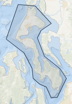
OK. The report isn’t about Whidbey Island exclusively, or even as a separate document. But, they provide a tool that lets any of us draw a line in the water and find out what’s there. Your results will vary.
Let’s start with the water. It is the Pacific Ocean, but not the sunny, warm California version. This water comes down from Alaska and warms up to 50F. And yet, some islanders regularly go skinny-dipping without having to wait for Polar Bear events. Few will think less of those who wear swim suits, wet suits, or even dry suits (for those cautious wind surfers.) There are those who surf, but the protected waters of the Salish Sea are more sedate than coastal breakers.
Cold water grows big animals. It’s a thermal mass issue. If you want to visit a whale or a giant octopus forget skinny-dipping and wear those suits. The diving isn’t tropical, and the fish may not be as colorful, but they are large and impressive. Sea life is one reason there’s such a large industry in harvesting salmon, tuna, Dungeness Crab, and halibut. There are also shellfish farms, like Penn Cove Shellfish. Life fresh seafood? It’s hard to get fresher than seeing the pens from your dining table. Locals also harvest a bit, but don’t be surprised if it takes a bit of work. Geoduck (and that’s gooey-duck, not geo-duck) clams can weigh up to three pounds, and live three feet down in the muck. Wander along the low tide line and see people doing ridiculous things to grab one from below sea level. Not a catch and release event. 
Cold water also grows big plants. Bull kelp grow almost a foot a day, something the local seals and otters appreciate as they pick and choose from the various critters that climb the leaves and stems. The list of edible sea vegetables is enough to inspire more than enough classes, recipes, and opportunities for culinary explorations.

Both under the water and up on shore are dozens of protected sites for resident species, as well as migratory wildlife. It isn’t just birds. Whales pass through on the way between Mexico and Alaska. Whale watching tours are available, but sometimes the whales accommodate by dining within a hundred feet of shore. Inland, places like Crockett Lake have bird-watching stands. People watch the birds. The birds watch the people. Maybe they should build some people-watching stands.

On a quiet day, the Sound can look like it was a thousand years ago. But the west side of the island is bordered by the official shipping lanes in Admiralty Inlet. Just like on the land, keep to right. It applies to ocean-going vessels visiting the harbors of Everett, Seattle, and Tacoma. MarineTraffic.com can show a parade of cruise ships, Navy support vessels, carriers, subs, experimental craft, as well as, commercial fishing craft, mega-yachts, sail boats, power boats, float planes, container ships, bulk cargo, etc. And ferries, of course. Kayaks beware because the big ships might be traveling ten times faster than a person can paddle. The US Navy also gets worried when tiny craft get close to billion dollar warships. Through it all, the US Coast Guard keeps things organized, as well as searching and rescuing as necessary.

Those rescues are necessary because, even though the waters are calmer than the open ocean, dozens of major ships have sunk. The somewhat good news is that the waters can be so deep that hundred-foot-long ships can sink without being a safety hazard. The subs can probably maneuver around them fine.
There are a few lighthouses around, particularly at Bush Point and Admiralty Head; but don’t expect the towering spires from coastal sites. These don’t have to be seen far out to sea, just be seen by vessels trying to avoid hitting points of land. Enough useless bays exist that one is called “Useless Bay”, another is known as the site of a stranded mutiny (Mutiny Bay), and Cultus Bay might be translated as Foolish Bay, a name from before deep-draft European ships entered the area. Even kayaks and canoes can get grounded.

As for oil and gas sites, there are none; but there is an effort to turn the tides into a renewable energy source thanks to tidal power. Stay tuned for that. There may not be fossil fuel production; but decades of use have created dumps and haz-mat sites that are best left unperturbed. That’s especially the case for the nearly dozen sites containing unexploded ordnance. Wars happen, and the upper left corner of the lower 48 has been a natural place for military bases, bases which sometimes practice by bombing home surf and turf. Those days are gone, but the bombs remain.
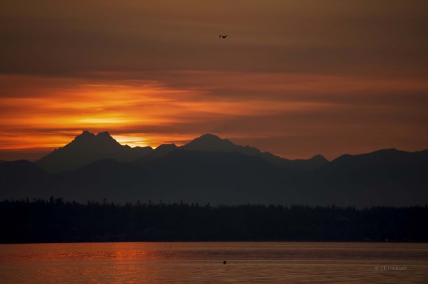
Regardless of the data and what it reveals, most islanders are islanders because it’s an island; and islands are defined by their waters. Wander to the shore at sunset and watch the waters calm, the colors deepen, and the world turn. Even for those who don’t sail it, fish it, and swim in it, Whidbey Island’s waters are priceless, and appreciated.