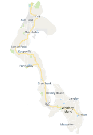
Keep a sense of humor here, folks. This isn’t about red light districts, but which districts on Whidbey Island have red lights. There are so few, they’re worth noting. Imagine that, a life (or at least a drive) without red lights.
 The biggest red light district is Oak Harbor. No surprise, there. It’s a city. Shops, neighborhoods, big box stores, and tens of thousands of people living on each side of State Route 20, the longest state route in Washington State. Few probably travel its length, but those that do get to see the Olympic Mountains, Port Townsend, Whidbey Island, a dramatic passage through the North Cascades (for the several months of the year when the snows haven’t closed it), the Methow valley, and a long line of northern Washington towns ending by Idaho. And, it is the main road through Oak Harbor. Of course it has lots of red lights; just like any other city.
Heading north from the naval air station, that’s about it except for one light at the entrance to Deception Pass State Park, the state’s most visited state park, hence the need for a light. That’s about ten miles of highway without signals starting and stopping traffic. The main worry is traffic as drivers bounce between two-lane and four-lane stretches.
Drop all the way to the bottom of the other major road, State Route 525, to where it meets the island at the Clinton Ferry terminal. Okay, so there is a red light right at the end of the dock, but that’s to keep the pedestrians safe as both people and cars get on and off the island.
From there, it’s about two miles to a light at Ken’s Corner, over nine miles to a light in Freeland, and a total of 27 miles before the light at Coupeville. Start at the end of the ferry terminal and that’s almost 27 miles with only those three lights, another at Maxwelton, another at Bayview. Anything less than 27 would seem spartan in most cities. Along Whidbey’s highways, the average is far less. It’s almost as if each small town got an allotment of at least one light, with Langley missing out except by the proxies of its access roads. Greenbank misses out, but make sure you slow to 45mph as you pass through.
The red lights stop traffic along and across the highways, but for many islanders it’s possible to avoid even those few lights. Drive from Cultus Bay to downtown Langley and it’s either ten miles crossing at one light, or a couple miles longer crossing at stop signs on smaller roads. Extend the trip to Fox Spit or Baby Island and go more than fifteen miles. It’s possible to commute or run errands with only having to stop at signs, not lights.
Red lights are not evil, they just feel that way when you’re in a hurry. They seem to forget to use the other colors when you’re sitting there trying to get to some other there. Stop signs never change color, but they do require patience; especially, when the ferry line finally snakes its way past your intersection. (Watch for the motorcycles. They off-load first and lead the pack as it disperses itself into the island.)
It’s a little thing, the sort of thing that’s absence is hard to notice until dropped back into a city with lines of cars, turn only lanes, and drivers who are more interested in their smartphones than whether the light has turned green. Whidbey’s lack of red lights is the corollary to the two lane lifestyle. A little different, a little slower, a little freer, an island pace and an island style.


I used to have a very early morning commute from Greenbank to Oak Harbor. As I set my cruise control while passing the Greenbank Farm I’d anticipate if I would “get lucky” and not have to touch the brakes as I passed thru Coupeville. Surprisingly there were very few times the Coupeville light was red, making my trip from Greenbank to the Fort Nugent light with no change in speed! Made for a fun little game.
LikeLike