
Pardon the lack of photos, but sometimes it is more prudent to Not clutter up a disaster site by visiting to get pictures. During the recent King Tides too many roads, houses, and even dikes were inundated by too much water. Locals who live by the seashore can tell their stories. Curious folks can check the news for articles about a few isolated incidents. But after the tides recede there are ways to check for evidence of what happened, where, and whether it might happen again. And there might be ways to witness the next one without getting in the way.
Whidbey is an island by the sea, with great views of the water. Naturally people want to enjoy that natural view, so they live there. Some farms and pastures are down by the water on old flood plains, some reclaimed behind dikes. Roads skirt the shore along stretches that attract tourists and locals who value scenery over speed. It makes sense that too much water was hard to ignore.
Every day has high tides, some higher than others thanks to astronomy. Storms generate waves, which lift water because waves aren’t flat; otherwise they wouldn’t be waves. Storms can also lift oceans as low pressure doesn’t press down as hard. Take an exceptionally high tide, and it gets called a King Tide. Add a storm that brings low pressure, and that tide gets lifted. Check weather forecasts about storm surges and know that they can happen anywhere. Add wind and get something much more than what shows up on the tide calendar.
Water that was held back by seawalls can flow across roads, over dikes possibly breaching them, and even onto yards or into houses. That happened. The estimates for sea level rise continue to change and increase, so to some extent, King Tides are an opportunity to see how vulnerable some areas are.
Or, so much of the island is inland and high enough that it wasn’t an issue until folks heard about it on the news or in the grocery line – or worse yet, in the line at the hardware store as a homeowner is buying materials to repair something they care about.
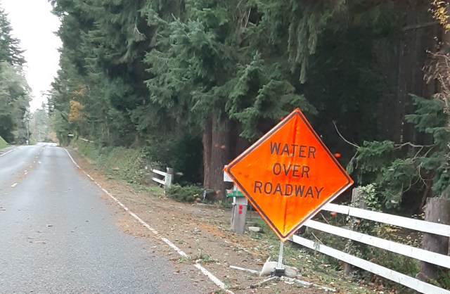
Islanders are accustomed to compromise and adaptation. Some roads are even marked by signs that mention Water Over Roadway during normal high tides. Some businesses actually benefit from being at sea level, like ship builders like Nichols Brothers. No deep harbor? Wait for the water to come up and launch then. Adapt.
Another hint that you are driving across or near low land are the Tsunami Evacuation signs. You may not be able to see the water from the road, but they may meet from a quake. Places like Bayview seem to have silly names until you realize that a dike on the horizon means the road goes across dry land, and maybe even some pasture, but at one time was a place for boats to bring in supplies. Now, cattle graze there.
The aftermath will be unnoticeable in many places, but in others it will be obvious for a while. Construction tape and cones mark off repair sites. Contractors’ truck cluster around seaside businesses, government facilities, and residences. Look along the shorelines and see driftwood stacked and scattered in tonnages that would be difficult for humans to haul, but that nature can lift and sweep along as wind and waves redistribute old trees. Visit Mackie Park in Maxwelton and see a sandbar left by storms years ago that redefined whether the park has a boat launch for something like a kayak. And then consider that another storm could clear it away. The most subtle evidence can be the debris line left from the furthest extent of the tide, a line of something as innocuous as pine needles and small branches in the parking lot of a marina – proof that the marina may have been flooded. In at least one marina, you had to walk up a slight ramp to get onto the dock. The boats, of course, floated. The dock, well, that was a variable.
So, why mention this after the storm is gone? Because it can explain lots of those construction, really repair, sites. And because King Tides happen on a regular basis. Storms are less predictable, but happen often enough; and because, storm chasers may be able to enjoy vantage points that are safe and engrossing. But find someplace with some elevation on a stable slope and clear access, and out of the way of the folks who have to get to work. And, if you want the best stories, talk to the locals. There was that one driver whose car floated around some curves yet somehow steered itself onto the road rather than the beach. Amazing.
The next King Tide? Sometime around January 22 or 23. Whidbey is such a long island that the north end is north of the Port Townsend station, and the south end can benefit by checking the station in Seattle. Be safe. Stay dry. Good luck.
