
“It is too easy to stay within self-imposed, arbitrary borders…”
Whidbey Island, one big happy small-town community. Nice idea. Drop by most coffeeshops, or any place where eavesdropping can’t be avoided and eventually hear something like, “I love Whidbey, but I won’t go any farther north or south of fill-in-the-blank road.” Sounds provincial, doesn’t it? Not really.
Whidbey Island is one of the longest islands within the contiguous 48 states of the United States. Chambers of Commerce and tourism bureaus make claims for being the biggest, or the longest, or whatever. Whether Whidbey is extreme geographically isn’t important. It is long enough and it is big enough to break up into many neighborhoods.
Consider what most cities consider to be a neighborhood, a collection of houses that have some common identity. There are no universal rules, but wikipedia suggests;
“Size the neighbourhood to sufficiently support a school, between 5,000 and 9,000 residents, approximately 160 acres at a density of ten units per acre.” – wikipedia
That’s 1,600 houses and probably about 3,200 people in a quarter of a square mile. Nicely manageable. Easy enough to walk around. Probably just about right to support a few small shops.
Consider Whidbey Island. The road from north to south is over 50 miles, the land area is over 168 square miles, and yet has fewer than 100,000 people. Even Whidbey’s urban areas are sparse in comparison to Big Cities. A city the size of the island would hold over two million people, a little less than the population of New York City. The distance from Brooklyn to the Bronx is less than the distance from the Clinton ferry to Greenbank, or Deception Pass to Coupeville.
With Big Cities in mind, the fact that Whidbey ‘only’ breaks itself into about three distinct areas is rather egalitarian.
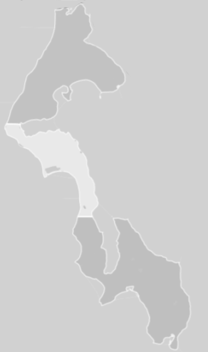
Look at the real estate regions. There are three. Their borders are about where most residents draw their lines: North Whidbey extends down to about Penn Cove, South Whidbey extends up to about Greenbank Farm, and Coupeville sits in the middle wondering what all the fuss is about.
Each can stereotype another, but each also has some aspect of the other as well. There’s plenty of rural land in the north end. There are few almost-Big-Box stores on the south end. There’s art throughout. There are views, too. Take your pick of jets, fighters near the Navy base, jumbos from Everett flying over the Clinton ferry.
While some see the divisions as divisive (which they are), they are also opportunities. What’s your preference? Living on Whidbey Island offers so many choices that it can take a while to recognize which area works best for you, and then which community or complete lack of community is best for your lifestyle. Some visitors only explore the first few miles from either ferry or the bridge, and assume the rest of the island is filled by copy and paste. Maybe that’s all they have time for. Even most residents haven’t explored the entire island. There’s so much to do in each area that it is easy to never drive to Cultus Bay on the southern tip, out near Baby Island at the entrance to Holmes Harbor, or over to Dugalla Bay.
We draw lines on maps and in our minds, but they’re really not there. Roam about a bit but recognize the one border that truly defines the island, the shore. Driving past that one without a bridge or a ferry is far from arbitrary.
