I live at 115 feet above sea level. Oh, wait. Now it’s 114 feet. Oops. Try 120 feet. You’re welcome to ignore “steady as a rock.” Whidbey Island’s land and seas shift enough to excuse some for thinking it’s a ship instead of an island. Most of those shifts, however, are so slow that no one notices – but there’s one or two that can come as surprises.
Heard about global warming and climate change? How can you miss the topic, regardless of your position on it? The atmosphere is warming. The oceans are warming. Heat up water and it expands. The sea level rises. But how much? In places like Miami, they’re expecting up to 5 feet of rise by the end of the century. That’s significant in a place with an average elevation of 4.4 feet. Oops.

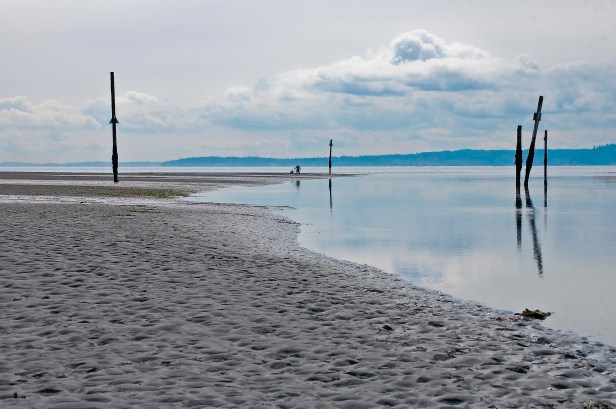
Whidbey’s land is taller than that; but Whidbey is also known for seaside properties, places where people track sand into their living room after a walk on the beach. So, worry? Depends.

Look at a map of the Puget Sound. It is a big long lobe of liquid water that was carved by a big long lobe of solid water. Here’s where the most recent ice age ended. The shore is roughly the outline of the greatest extent. Maybe someone should write an epic novel about the wintry white attacker from the north; but it was really ‘just’ a few thousand feet of ice that carved broad land down to bedrock and gravel, then retreated to create an enormous freshwater lake that switched to saltwater as the glacier pulled back north of Port Angeles. From solid water thousands of feet thick to liquid water hundreds of feet deep, don’t be surprised that in between the shorelines were highly variable. For a while, Whidbey wasn’t an island, then couldn’t see the sky, became an archipelago, and now is the island we know.
Water is heavy. In particular, the ice pressed the land down into the tectonic plate. The retreat happened within a few thousand years, but more than ten thousand years later the land continues to bounce back. Granted, it is a slow bounce. As the land rises, the sea relatively shrinks, or at least has that opportunity.

Without the land rise, the sea rise would be greater. Rise enough and the island breaks into islands again. Given enough time, that may happen. Add the up and down together and get a much smaller number than many regions are worried about (about a 50% chance of a 2 foot rise.)
Ah, but the land and the sea move in more ways than those.
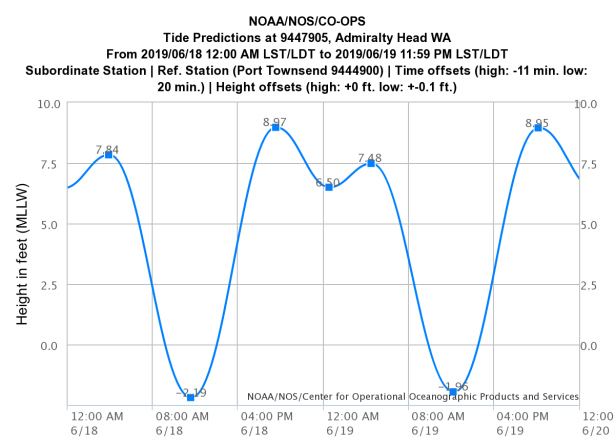
It varies daily, but the tides quietly inundate the Puget Sound with up to twelve feet of water stretching scores of miles. Six hours later the level drops back. Six hours later it returns. Repeat, roughly. The waves can be easy to miss, but truly tidal waves of water wash the Sound twice a day. Throw in some wind or a low pressure system, and a few feet of storm surge can move water beyond unprotected beaches.
Even more quietly, almost always, is the big one. The place where tectonic plates scrape one under the other, accumulating energy is a geological spring. For hundreds of years the Juan de Fuca plate is shoved under the North America plate, piling up sediment along the underwater coast, and feeding the mantle that melts the rock that can rise up into the mainland’s volcanoes. Quake do more than shake. Subduction quakes also raise and drop the land, depending on which side of the fault the land is on. In a similar situation in Fukushima, Japan, the fault itself dropped the land side dozens of feet as it sprung out over a hundred feet. On shore the effects were smaller, but a drop in land helped water move far past the shore. Whidbey is far from the subduction zone, but shifts will happen.
Subduction quakes are known for generating tsunamis. Tsunamis are hard to stop, but they’re not guaranteed and they’re hard to predict. Fortunately, local ones come with their own early warning system called the earthquakes. Feel the shake? Run up hill – that is, if you’re in a low-lying area. Those tsunami signs around the island are for real – and very rarely needed.
There are other ways the land and the sea move in the Sound. Slides happen, which can trigger smaller, though just as dangerous, tsunamis. One on the south end of Camano Island devastated a village on Hat Island. The Sound comes equipped with the Seattle Fault and the South Whidbey Fault, which are smaller that the Juan de Fuca system, but they’re our underground neighbors.
And yet, with all those influences up and down, and in and out, an individual wave is more noticeable than any of them. A man and his dog may go for a walk on the beach beside water that’s as still as a quiet mountain lake. Just don’t stand at the low tide line too long. Tides don’t wait for us to move.