
Whidbey is an island known for its views. Look east and see the Cascade Range and three volcanoes. Look west and see the Olympic Mountains or a saltwater horizon. The east and west views are particularly appealing at an equinox, the two days each year when the Sun rises and sets (almost) exactly to the east and west. No need for a compass. No need to guess which way you’re looking – weather permitting.
It shouldn’t be surprising that the Spring Equinox hides behind clouds, but not always. Sometimes it allows a glimpse before a cloud bank sweeps in from the Pacific.
Ask most islanders to draw a line between the north and south halves of the island and get a series of scratches from north of Coupeville to south of Greenbank. For something more definitive, visit the middle latitude that happens to run through Admiralty Head. The name may not be familiar to most, except for lighthouse enthusiasts. Also know the place as the Coupeville or Port Townsend (or for long-term residents, the Keystone) ferry terminal. Military historians may know the place as Fort Casey and Camp Casey, a site built to defend Puget Sound. Movie buffs may know the area as the site of scenes from Officer and a Gentleman.

For people seeking westward views, Admiralty Head helps draw the line between views of the Olympic Mountains or those saltwater horizons. Which do you prefer: views of silhouetted mountains at sunset or great open expanses that channel whales and ships into the Sound?

On each Equinox, the distinction is clear – weather permitting.
The views from Whidbey attract people from around the world. Some come to visit, and may exercise their camera, maybe with the aid of the local art instructors. Some decide to stay, and join the others looking for that prime and personal space that looks out on a landscape or seascape.
As much as it would be a treat to create a suite of sunrise and sunset photos, the effort would require teams of photographers. One person trying to chase the sunset will find the more than hour long drive from top to bottom to be too much. Fortunately, there’s a tool for hinting at what’s available, and where the Sun hits the horizon.
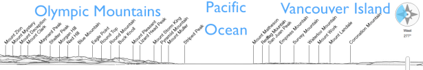
Peakfinder.org is an impressive tool. Enter a location, and it provides a sketch of the horizon. Shift it around the compass to check out every direction. Add in the layers of the Sun’s and Moon’s paths, and get an idea of what’s available without having to commit to visits throughout the year (even though that could be appealing for other reasons.)
The views aren’t only to the east and west, of course. North and south have views too, but because the island is long and skinny, much of the time the views are of the rest of the island. Get far enough south, and look down the Sound to Seattle’s skyline, and Mt. Rainier which dwarfs it. Get farther north, and a west view includes Canada. Whidbey Island is far enough north that some parts look slightly south to see across the border.
There are plenty of views within the island, too. Harbors, bays, lakes, ponds, valleys, and prairies all have their champions.
The equinoxes aren’t the only times to see the views, but they are great opportunities to enjoy a bit of the planet’s balancing act. If you want to see the extremes, well, check out the solstices. Those sunrises and sunsets wander far in three months, making every view unique every day.
PS Gardeners may like the tool for getting a feeling for how much sun their plants will get – weather, trees, and neighbors permitting.
